• Date:2022-07-06

Forest dynamics is an important topic in the current forest ecology research. To explore the underlying mechanisms that generate the diversity and the spatial or temporal dynamics of forest community, ecologists from the Center for Tropical Forest Science (CTFS) developed a forest monitoring methodology that is different from the traditional vegetation studies. They established large permanent plots called “Forest Dynamics Plot” (FDP; typically 25 to 50 ha) and conducted regular censuses (including tagging, measuring, identifying and mapping) of all tree with diameter >1 cm in the plots. The global FDP network integrated by the CTFS now monitors 4.5 million trees of approximately 8,500 species in 53 plots across temperate, subtropical and tropical forests in 23 countries.

Since 1996, the Taiwan Forestry Research Institute (TFRI) has sequentially established three FDPs in the northern (Fushan), central (Lienhuachih), and southern (Kenting) parts of Taiwan, in collaboration with the Forestry Bureau, the National Taiwan University, the National Dong Hwa University, the Tunghai University, and the Taiwan Academy of Ecology. These plots are now managed by the TFRI, and the Fushan and Lienhuachih plots have been incorporated into the global FDP network. For more details about FDP and the tree-census technique, please visit the CTFS website.

  • Date:2022-07-06

Introduction

The Fushan Forest Dynamics Plot (FDP) is a 25-ha permanent plot established in an old-growth submontane broad-leaved rain forest in northeastern Taiwan (24°45'40"N, 121°33'28"E). This plot represents the first large forest plot in the subtropical bioclimatic zone in the world. From 2002 to 2009, we conducted the topography survey and the first and second tree censuses (2003-2004 and 2008-2009, respectively) within the plot, following a unified method adopted by the worldwide FDP network integrated by the Center for Tropical Forest Science.

The plot is square in shape, measuring 500 m (north-south) by 500 m (east-west). The elevation of the plot ranges from 600 m to 733 m a.s.l. According to the weather records (1993-2003), the annual precipitation averages 4,237 mm with no dry months; the annual average temperature is 18.2°C with a monthly average ranging from 11.9°C (January) to 24.1°C (July). In addition to great amount of rainfall, there are 227 rainy days per year and a high relative humidity of 95% on average, indicating an extremely wet climate.

Within the Fushan FDP, all woody stems with at least 1 cm diameter at breast height were identified, tagged, mapped, and measured. In the first census, 114,354 woody individuals (including 2,656 tree ferns) were investigated, comprising 39 families, 68 genera, and 110 species. The most species-rich families are Lauraceae (12 species), Aquifoliaceae (9), Myrsinaceae (8), Rubiaceae (8), and Fagaceae (7). In Taiwan's vegetation classification scheme, the forest belongs to the Machilus-Castanopsis zonation of broad-leaved forests in Taiwan.
The Fushan Forest Dynamics Plot is situated in a natural broad-leaved old-growth forest

The Fushan Forest Dynamics Plot is situated in a natural broad-leaved old-growth forest

The relief map of the Fushan Forest Dynamics Plot

The relief map of the Fushan Forest Dynamics Plot

Plot Data

Data from the tree censuses and topography survey of the Fushan FDP are accessible. The contents of the data include:

  1. Tree census: The tag number, species identity, diameter size, census date, and location of all woody individuals with at least 1 cm diameter at breast height;
  2. Topography survey: The survey data (x, y, z coordinates) of 1,710 stake points within the plot.

Applicants should contact Mr. Sheng-Hsin Su (eMail:sush@tfri.gov.tw) for further information.

The spatial distribution of the three main species in the plot

The spatial distribution of the three main species in the plot

Researchers

  • Sheng-Hsin Su, Taiwan Forestry Research Institute (plant ecology)
  • Prof. Chang-Fu Hsieh, National Taiwan University (plant ecology)
  • Prof. I-Fang Sun, National Dong Hwa University (plant ecology)
  • Dr. Chia-Hao Chang-Yang, National Dong Hwa University (seed rain, plant phenology)
  • Chia-Ling Lu, National Taiwan University (seedling dynamics)
  • Prof. Zueng-Sang Chen, National Taiwan University (soil science)

Partners

Forestry Bureau, Council of AgricultureInstitute of Ecology and Evolutionary Biology, National Taiwan UniversityDepartment of Natural Resources and Environmental Studies, National Dong Hwa UniversityCenter for Tropical Forest Science of Smithsonian Tropical Research Institute (CTFS)

  • Date:2022-07-06

Introduction

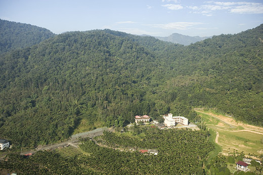
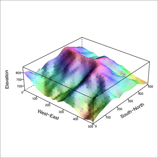
The Lienhuachih Forest Dynamics Plot (FDP) is the second 25-ha permanent plot in Taiwan. It is located in the 4th and 6th Forest Compartments of the Lienhuachih Experimental Forest (LEF) in central Taiwan (23º54’49”N, 120º52’43”E). The topography of the plot is characterized by hills with valleys, steep slopes, and ridges. The average slope of plots is about 35.3°, so the land is very steep. Topographic features display high spatial heterogeneity within the plot.

The climatic characteristics of this area are hot summers with warm winters, and the range of average monthly temperatures is small throughout the year. Moreover, it has a distinct dry season. The mean annual temperature is 20.8°C. The mean relative humidity is 87.1%. The annual precipitation is 2285.0 mm with seasonality. More than half of the rain falls between May and September (about 89.6% of the total rainfall). In terms of natural disturbances, on average, 0.7 typhoons pass by the area each year and often cause severe damage. Typhoons usually bring extremely heavy rainfall and result in over-saturation of soil water. Because of the steep slopes in this area, typhoons often cause serious landslides, which in turn influence the forest structure and biodiversity.

Following the FDP methodology developed by the Center for Tropical Forest Science, we set up this plot with a projected area of 25 ha. The plot is square in shape, measuring 500 m (north-south) by 500 m (east-west). The elevation of the plot ranges from 667 m to 845 m a.s.l. In the 25-ha plot, we identified, measured, tagged, and mapped every shrub and tree with diameter at breast height (DBH) of ≥ 1 cm.

In total, 153,268 (6131 stems/ha) tree individuals were recorded in the first tree census (2007-2008), belonging to 144 species, 88 genera, and 46 families (Table 1). The total basal area was 869.31 m2 (34.77 m2/ha). Except for two gymnosperms (Podocarpus nakaii and Pinus morrisonicola) and 1 monocotyledon (Arecae catechu), the rest of the woody species were all dicotyledons. In total, 29 species are endemic to Taiwan, for instance, Helicia rengetiensis and P. nakaii. In Taiwan's vegetation classification scheme, the forest belongs to the Machilus-Castanopsis zonation of broad-leaved forests in Taiwan.

The Lienhuachih forest dynamics plot located at west of the Lienhuachih research center.
The Lienhuachih forest dynamics plot located at west of the Lienhuachih research center.

The three-dimentional maps of the Lienhuachih forest dynamics plot.

The three-dimentional maps of the Lienhuachih forest dynamics plot.

Plot Data

The field teams measured all horizontal points at 20-m intervals within the 25-ha plot. The plot was divided into 625 quadrats of 20 m ×20 m, each with other subsidiary points at 10-m intervals. Each 20 m×20 m quadrat was further divided into 16 subquadrats of 5 m×5 m. All freestanding trees ≥ 1 cm in diameter at breast height (DBH) were mapped, measured, identified, and tagged.

Data from the tree census and topography survey of the Lienhuachih FDP are accessible. The content of data includes:

  1. Tree census: The tag number, species identity, diameter size, census date, and location of all woody individuals with at least 1 cm diameter at breast height.
  2. Topography survey: The survey data (x, y, z coordinates) of 676 stake points within the plot.

Applicants should contact Dr. Li-Wan Chang (EMail:liwanc@tfri.gov.tw ) or Mr. Sheng-Hsin Su (EMail:sush@tfri.gov.tw ) for further information.
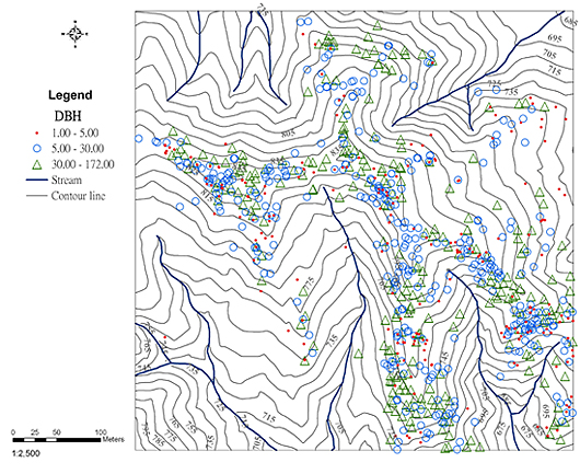
Distribution map of the different size of DBH of Lithocarpus nantoensis in the Lienhuachih forest dynamics plot.

Distribution map of the different size of DBH of Lithocarpus nantoensis in the Lienhuachih forest dynamics plot.

Researchers

  • Dr. Li-Wan Chang, Taiwan Forestry Research Institute (plant ecology)
  • Pei-Hsuan Lee, Taiwan Forestry Research Institute (plant ecology, fern phenology)
  • Dr. Jeen-Lian Hwong, Taiwan Forestry Research Institute (hydrologic characteristics of watershed)
  • Prof. I-Fang Sun, National Dong Hwa University (seed rain, seedling dynamics)
  • Teng-He Huang, Tunghai University (seed rain, seedling dynamics)
  • Prof. Kuoh-Cheng Yang, Providence University (plant Taxonomy)
  • Prof. Zueng-Sang Chen, National Taiwan University (soil science)

Partners

Forestry Bureau, Council of Agriculture

  • Date:2022-07-06

Introduction

The Kenting Forest Dynamics Plot (FDP) project was initiated in 1996 by the cooperation between Dr. Sun I-Fang and the Heng-Chun Research Center, Taiwan Forestry Research Institute. When the plot was first established in 1999, it was only 6-ha in size owing to budget and manpower shortages, but then it was expanded to 10 ha in 2001 by the Heng-Chun Research Center. Based on the experiences and achievements from the first census, the Taiwan Forestry Research Institute finished the second tree census smoothly from January to October in 2008. The Institute also set up 72 seed traps in 2006 and 144 seedling plots in 2007 for long-term monitoring works in collaboration with Dr. Yi-Ching Lin. In addition, preliminary research for soils in the plot was conducted by Dr. Hseu Zeng-Yei Hseu from 2004 to 2005.

The Kenting FDP is located in a relatively undisturded monsoon forest in the northeastern part of the Ken-Ting Karst Nature Reserve (120°49'06"E, 21°57'55"N; ca. 250-300 m a.s.l.). It is a 10-ha rectangle of 400 m long (east-west) and 250 m wide (north-south). The topography is characterized by many ravines, caves and solution valleys. The differences in elevation between two stakes can be 20 to 50 m due to the sharply undulating nature of karst terrain. The climate in Kenting is clearly divided into dry and wet seasons. According to weather data in 2000-2010, the average annual precipitation is 2,000 mm. About 87% of the rainfall occurs between June and November, while the months of October to April are drier with strong northeast monsoon. The mean annual temperature is 25.4°C and the difference between the average temperature of the coldest and hottest months is small, from 20.9°C in January to 25.4°C in August. On average, 2.3 typhoons invaded the Hengchun Peninsula every year from 1897 to 2007, and the forests and vegetation covers had often suffered mechanical damage and heavy rainfall.

The topography survey and tree census works of the Kenting FDP were conducted basically following the methodology developed by the Center for Tropical Forest Science. But for investigation of the numerous huge prop roots of Ficus benjamina and F.microcarpa in the plot, we made some modifications on the method. During the second tree census, all independent prop roots of the two Ficus species with a minimum DBH of 5 cm were treated as “stems”. That means that they were tagged, measured and mapped as an ordinary tree stem was.

According to the results of the 2008 tree census, a total of 39,093 individuals belonging to 34 families, 74 genera, and 95 species were recorded in the plot. Most trees are tropical species of Euphorbiaceae and Moraceae; 19 species are endemic to Taiwan, and 10 species are rare species. The most abundant families in terms of density are Ebenaceae (23,140 individuals) and Euphorbiaceae (6,113 individuals). The abundance and the dominance in the plot are concentrated in few species wherein Diospyros maritima is the absolute dominant species with 22,079 trees (56.4%) of all individuals and a basal area of 101.6 m2 (22.5%) of the total basal area. In Taiwan's vegetation classification scheme, the forest is close to the Ficus-Machilus zonation of broad-leaved forests in Taiwan, but unique in its mono-dominance of D. maritima.

Kenting forest dynamics plot is located in the Kenting Uplifted Coral Reef Nature Reserve of the Kenting National Park.

Kenting forest dynamics plot is located in the Kenting Uplifted Coral Reef Nature Reserve of the Kenting National Park.


The relief map maps of the Kenting forest dynamics plot.

The relief map maps of the Kenting forest dynamics plot.

Plot Data

Data from the tree censuses and topography survey of the Kenting FDP are accessible. The contents of the data include:

  1. Tree census: The tag number, species identity, diameter size, census date, and location of all woody individuals with at least 1 cm diameter at breast height;
  2. Topography survey: The survey data (x, y, z coordinates) of 1,066 stake points within the plot.

Applicants should contact Ms. Shu-Hui Wu (EMial:Send an Email to Ms. Shu-Hui Wu) or Mr. Sheng-Hsin Su (EMail:Send an Email to Mr. Sheng-Hsin Su ) for further information.


The tree map of Diospyros maritima in the plot.

The tree map of Diospyros maritima in the plot.

Researchers

  • Shu-Hui Wu, Taiwan Forestry Research Institute (plant ecology)
  • Dr. Hsiang-Hua Wang, Taiwan Forestry Research Institute (plant ecology)
  • Dr. Yi-Ching Lin, National Tunghai University (plant ecology)
  • Dr. I-Fang Sun, National Dong Hwa University (plant ecology)